
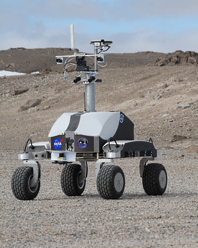
Figure 2 - NASA’s K10 autonomous or teleoperated rover designed for robotic site survey, at speeds up to 0.6 m/s. (Houghton Crater K10 Field Test, 2010) [NASA/ARC/NLSI].
Pedersen & Allan, et al.
NASA Ames Research Center
Carnegie Mellon University
Humboldt University
ETH, Zurich
Increased navigation speed is desirable for lunar rovers, whether autonomous, crewed or remotely operated, but is hampered by the low gravity, high contrast lighting and rough terrain. We describe lidar based navigation system deployed on NASA’s K10 autonomous rover and to increase the terrain hazard situational awareness of the Lunar Electric Rover crew.
Introduction - High speed mobility (by planetary rover standards) is desirable for more efficient exploration of the lunar surface, particularly if human crews are present there.
NASA’s Lunar Electric Rover (LER) can drive at 10km/h (3m/s) on rough terrain, faster on known smooth surfaces. By comparison, the MER vehicles moves at a few cm/s while stopping regularly.
 Driving on the Moon is complicated by the low gravity, rough terrain, high contrast lighting and alien environment.
Under the 1/6g lunar gravity a vehicle becomes airborne at relatively modest speeds (driving the Apollo era lunar rover at 7 mph was reportedly like being aboard a rowing boat for this reason). The reduced gravity also lessens vehicle-ground friction. Together these effects increase maneuvering distances.
Astronauts complained of difficulty discerning surface features on the Moon under certain lighting conditions, such as with the sun behind them. The lack of terrestrial depth cues compounds the difficulties of driving.
The 3 sec signal round trip time delay to the Moon permits tele-operating a vehicle from Earth (e.g. Lunakhod) with diffculty (increasing with speed).
This paper describes our robotic rover navigation systems, currently running on NASA’s autonomous or teleoperated K10 rover (Figure 2) and as a crew aid on the LER for increasing pilot situational awareness of the surrounding terrain. We address terrain sensing for 4 different classes of rovers: K10, the Lunar All Terrain Utility Vehicle (LATUV, Figure 3), the LER and the LER operating under lunar gravity and time-delayed tele-operation.
Subsequent sections describe the terrain mapping and hazard detection software, pose estimation, the rover software infrastructure for command and data handling, the graphical user interface and performance figures.

Figure 8 - Apollo 17 Station 3 high-resolution pan centered on the south rim of Ballet Crater; frames AS17-138-21155 through 21167 assembled by David Harland for the Apollo Surface Journal [NASA/JSC].
i-SAIRAS 2010. 10th International Symposium on Artificial Intelligence, Robotics and Automation in Space - Sapporo, Japan, August 29 - September 1, 2010
i-SAIRAS 2010. 10th International Symposium on Artificial Intelligence, Robotics and Automation in Space - Sapporo, Japan, August 29 - September 1, 2010
No comments:
Post a Comment