
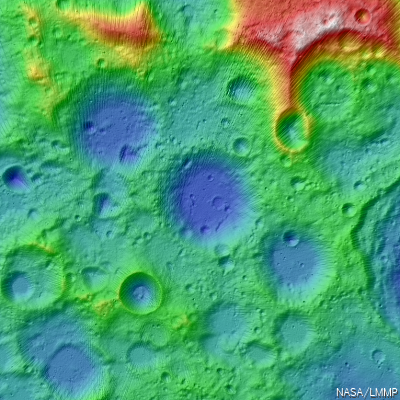
No longer 'no man's land,' the Moon's south pole and vicinity unseen before the 21st century swept up by laser altimetry over multiple orbital passes of the LOLA instrument on-board the Lunar Reconnaissance Orbiter (LRO). Most of the lower elevations shown above are permanently shadowed. This false-color and hill-shade view of the LOLA Digital Elevation Model (DEM) is a small example of what can now be very easily accessed on-line by way of the Lunar Mapping and Modeling Project (LMMP), already a very thorough public resource under development by NASA.
Kimberly Newton
Marshall Space Flight Center
NASA has created a new interactive web-based tool that incorporates observations from past and current lunar missions creating one of the most comprehensive lunar research websites to date.
The Lunar Mapping and Modeling Project at NASA's Marshall Space Flight Center in Huntsville, Ala. has created an online set of capabilities and tools that will allow anyone with an Internet connection to search through, view, and analyze a vast number of lunar images and other digital products. The data and tools available through the project website will allow researchers to perform in-depth analyses to support mission planning and system design for lunar exploration and science missions. It will permit detailed scientific analysis and discovery and open additional educational and outreach opportunities.
The project website is a one-stop location for finding, retrieving, and analyzing data about the moon, including the most recent lunar surface imagery, altimetry, temperature, lighting and other data, as provided by the Lunar Reconnaissance Orbiter (LRO) and its seven onboard instruments.
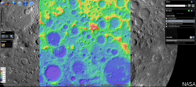
A postage-stamp-sized reduction of the LMMP user interface as viewed through most browsers shows the LOLA color-coded and hillside shaded elevation of 75 degrees south layered over, in this example, the LROC Wide Angle Camera (WAC) monochrome mosaic [NASA].
The orbiter, launched by NASA in 2009, continues to gather information about the moon from its orbit some 31 miles (50 kilometers) above the lunar surface. LRO has provided a treasure trove of data -- more than all previous lunar and planetary missions combined.
The Lunar Mapping and Modeling Project website will also include data obtained from past lunar programs and missions including Apollo, Lunar Orbiter, Lunar Prospector, Clementine, Kaguya (Japan) and Chandrayaan-1 (India).
The Lunar Mapping and Modeling Project website will also include data obtained from past lunar programs and missions including Apollo, Lunar Orbiter, Lunar Prospector, Clementine, Kaguya (Japan) and Chandrayaan-1 (India).
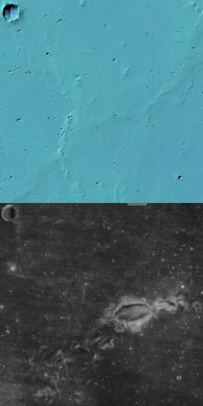
On the other hand, some lunar features can only be seen to be appreciated. As previously demonstrated, the Reiner Gamma lunar swirl, a nearside landmark in Earth-side telescopes, is invisible in the LMMP LOLA DEM layer, but shows up instantly when, with a click of the mouse, the present LMMP base map Lunar Orbiter/Clementine hybrid photomap is brought to the surface.
No comments:
Post a Comment